 Chen Liu
In This Guide
I was drenched in sweat, clutching a ticket stub, and squinting at my phone. Google Maps had promised a 'nature reserve' located somewhere in the green void. Ten minutes later, our van was stuck at a padlocked gate — with no entrance in sight. That was my first lesson teaching me to always have a White-Headed Langur National Nature Reserve map that actually shows the access points.
Most visitors assume this is a single fenced park like an African safari. It's not. The reserve is a patchwork of protected karst forest across Chongzuo, Guangxi. The map you need is not the one on Google Maps (which is outdated and often shows nothing but a blank patch). You need the official ecological tourism area map combined with AMap (高德地图) or Apple Maps. Here's the blunt truth: the visitor center and main trailhead sit near Banli Township (板利), about 60 km south of Chongzuo city. Without the right map, you'll waste hours on village dead-ends.
Let me save you that pain. Below is everything I've learned from leading foreign visitors to this reserve, including how to read the map, which trails are worth the walk, and how to spot the white-headed langur without falling for tourist traps.
Why You Need the White-Headed Langur National Nature Reserve Map
The official reserve map isn't just a navigation aid — it's a survival tool for the region's patchy phone signal and confusing rural roads. I've seen too many travelers open Google Maps and immediately get lost. Google Maps often points to a random point on the highway, not to the actual visitor entrance. The official map, which you can get at the Banli visitor center or download as a photo from the WeChat mini-program, shows the reserve divided into core and buffer zones. The only public access points are clearly marked. Memorize these before you head out.
- The visitor center at Banli Township: this is the main start.
- The ecological trail: a 2-3 km loop that climbs up the hillside.
- Three observation platforms: marked with binocular symbols.
- A restricted 'core zone' area: you'll see a bright yellow line — do not cross it.
Pro Tip: Download the map on your phone while you still have Wi-Fi. Inside the reserve, 4G is weak or absent, and your international SIM might not connect at all.
How to Read the Official Reserve Map
Grab the printed leaflet at the ticket office and keep it as your main reference. The map uses simple icons: a brown dashed line for the main trail, green circles for karst viewpoints, and blue triangles for seasonal water points. Here's what each actually means on the ground.
Trail Markers and Distances
The trail distances on the map are measured in kilometers but feel longer than they look. A '1 km' sign means about 15-20 minutes of walking on uneven stone steps, not a flat sidewalk. Plan for at least half a day if you want to slow down and watch for langurs.
Observation Platform Labels
The map marks platforms as '观猴点'. The most reliable one for first-timers is Platform No. 2, which faces a valley where troops feed on the hillside. Platform No. 1 requires a steep 15-minute descent and is harder for beginners. Platform No. 3 is often closed for maintenance — check the status at the visitor center.
Key Viewing Spots to Target on the White-Headed Langur Map
If you only have three hours, target these three mapped spots — they give you the highest chance of a sighting, but your mileage may vary.
Spot 1: The 'Golden Ridge' Viewpoint
This is the first spot after the trail splits. The map shows it as a semicircular terrace. Arrive before 8 a.m. when the langurs are still active — by 10 a.m. they vanish into the forest shade. I once waited here with a family from Australia for 45 minutes, and a whole troop of seven langurs moved right across the ridge. The light was perfect for photos.
Spot 2: Banli Township Viewpoint (near the visitor center)
If you're short on time or traveling with kids, skip the long trail and go straight to this small hill behind the visitor center. It's not on every map version, but ask the staff to point you to the '寨后' path. It's a steep 10-minute climb, but the view is worth it.
Spot 3: Patrol Road Vista
This is an unpaved forest patrol road that appears as a thin grey line on the map. It's open only to official vehicles, but you can walk along the edge. Be careful: the shortcut sometimes cuts through scrubby bushes where fire ants are common. Wear closed shoes and stay on the visible path.
How to Get to the White-Headed Langur National Nature Reserve
Getting to the reserve isn't as hard as it sounds, but it's easy to overpay if you don't know the options. From Chongzuo city, you have three main routes. Here's a cost-benefit table to help you decide.
| Transport | Time | Approx. Cost (RMB) | Best For |
|---|---|---|---|
| Taxi / Didi (from Chongzuo) | 50–60 min | 120–150 | Small groups, direct door-to-door |
| Local bus (from Chongzuo South Station) | 90+ min | 20–30 | Budget travelers with time |
| Private car + driver (half day) | flexible | 300–400 | Photographers and families |
| Organized tour from Nanning | 4–5 hrs | 500+ per person | Those who want zero planning |
Note: The bus drops you at Banli township, but you still need a local motorcycle taxi (about 10 RMB) to reach the visitor center. The driver will try to charge 30 RMB — negotiate.
Pro Tip: Use AMap's 'Go to' function with the Chinese name 白头叶猴生态旅游区. Do not rely on English maps. Show the driver the Chinese characters and the map screenshot.
Tickets, Permits, and the WeChat Booking Hassle
The reserve requires a real-name ticket purchase — and yes, your passport is mandatory. You can buy tickets on the spot, but in peak season (October to December, when the weather is mild), slots can sell out. For foreigners, the easiest way is to book through Trip.com or with a local guide. The WeChat mini-program is still in Chinese and often rejects international cards. I've seen too many travelers turned away at the gate for not having a reservation. Don't be one of them.
Prices: Adult tickets are around 60 RMB, children 6-18 and seniors over 60 get half price, and children under 6 are free. These prices change without notice, so confirm before you go.
Insider Advice: If you can't get tickets through Trip.com, call your hotel's concierge. Many Chongzuo hotels can help you book through their internal channel. It's faster than trying to fight the mini-program.
Insider Tips for Spotting Langurs Without Getting Cheated
The two golden hours for spotting white-headed langurs are right after dawn and just before dusk — not midday. Even with a map, you'll miss them if you arrive at noon. The langurs feed on young leaves early, then rest in the canopy when the sun is high. I always tell my clients: arrive at 7 a.m., catch the morning activity, then head out for lunch.
Be careful about 'local guides' waiting at the parking lot. They'll offer to take you to a 'secret spot' for 200 RMB. Usually they just drive you to the same visitor center and tell you to walk fast. Save your money and stick to the official map.
Also, wear dull-colored clothing. Loud colors — especially bright orange — scare the langurs. The first time I brought a client wearing a neon pink jacket, the troop we were watching disappeared within seconds.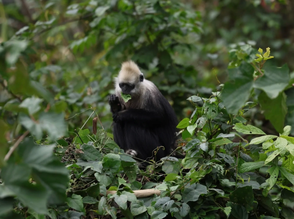
FAQ: White-Headed Langur National Nature Reserve Map & Trip Planning
Verified and fact-checked by the editorial team.






No comments yet.